Difference between revisions of "Hadrian's Wall"
m () |
|||
| Line 5: | Line 5: | ||
After the fall of the [[Roman Empire]], much of the stone from the wall was taken and reused building local [[churches]] and abbeys, as well as housing and farmsteads. However, Roman remains exist at points along the route - including a substantial length in the central, upland section. | After the fall of the [[Roman Empire]], much of the stone from the wall was taken and reused building local [[churches]] and abbeys, as well as housing and farmsteads. However, Roman remains exist at points along the route - including a substantial length in the central, upland section. | ||
| + | |||
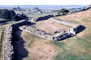
| + | Hadrian's Wall, also called 'the Roman Wall', was a massive structure built across [[Britain]] from around AD 120 on the orders of the [[Roman]] Emperor [[Hadrian]]. It marked the Empire's northern frontier. It crossed from near the mouth of the River Tyne, on the East coast, to the [[Solway Firth]] in the West. It had 'milecastles' spaced at a distance of every Roman mile, and two small turrets between each of these. Later, large forts shaped like playing cards were also built at intervals along the Wall. Sections of the Wall are preserved (though not at the original height of around 20ft), and forts like Housesteads, Chesters and Birdoswald are some of the most outstanding visible remains of the [[Roman Empire]]. The name of the last battle that [[King Arthur]] (allegedly) fought , Camlann, may derive from Camboglanna, one of the Roman fort names on the western part of the Wall. | ||
| + | |||
| + | [[Category:England]] | ||
| + | [[Category:Roman History]] | ||
== See also == | == See also == | ||
| Line 22: | Line 27: | ||
[[Category:Tourist Attractions]] | [[Category:Tourist Attractions]] | ||
[[Category:England]] | [[Category:England]] | ||
| + | [[Category:Roman History]] | ||
Revision as of 02:50, January 20, 2011
Hadrian's Wall was a wall built by the Romans across Britain in the 2nd century AD, to defend their northern frontier from Pictish incursions (an alternative theory is that is was not primarily a defensive structure but a tax barrier).
It stretched across northern England from Wallsend in the east to Bowness on Solway in the west, and formed the northern boundary of the Roman Empire, though a subsequent temporary northward advance took them as far as the Antonine Wall.
After the fall of the Roman Empire, much of the stone from the wall was taken and reused building local churches and abbeys, as well as housing and farmsteads. However, Roman remains exist at points along the route - including a substantial length in the central, upland section.
Hadrian's Wall, also called 'the Roman Wall', was a massive structure built across Britain from around AD 120 on the orders of the Roman Emperor Hadrian. It marked the Empire's northern frontier. It crossed from near the mouth of the River Tyne, on the East coast, to the Solway Firth in the West. It had 'milecastles' spaced at a distance of every Roman mile, and two small turrets between each of these. Later, large forts shaped like playing cards were also built at intervals along the Wall. Sections of the Wall are preserved (though not at the original height of around 20ft), and forts like Housesteads, Chesters and Birdoswald are some of the most outstanding visible remains of the Roman Empire. The name of the last battle that King Arthur (allegedly) fought , Camlann, may derive from Camboglanna, one of the Roman fort names on the western part of the Wall.
