File:Maps-of-the-lunar-poles-from-clementine.jpg
From Conservapedia

No higher resolution available.
Maps-of-the-lunar-poles-from-clementine.jpg (580 × 290 pixels, file size: 67 kilobytes, MIME type: image/jpeg)
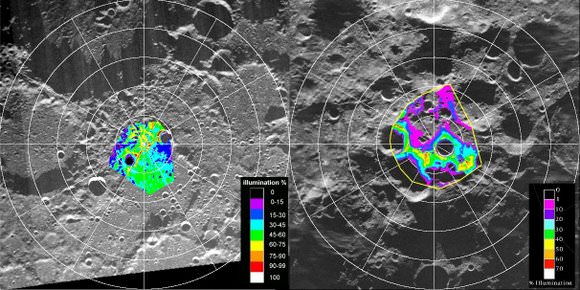
Infrared maps of the north and south Lunar poles, taken by the NASA spacecraft Clementine. Included are the views of the Aitken Basin that first suggested that ice might lie on the Moon.
Copyright information
This image is originally credited to NASA. As the work product of an agency of the United States government, this image is in the public domain. The photograph was then republished from Universe Today, whose terms are that all articles and images are reprintable so long as proper credit is given.
Source
Universe Today. <http://www.universetoday.com/wp-content/uploads/2009/06/maps-of-the-lunar-poles-from-clementine.jpg>
File history
Click on a date/time to view the file as it appeared at that time.
| Date/Time | Thumbnail | Dimensions | User | Comment | |
|---|---|---|---|---|---|
| current | 12:14, June 3, 2009 | | 580 × 290 (67 kilobytes) | TerryH (Talk | contribs) | Infrared maps of the north and south Lunar poles, taken by the NASA spacecraft ''Clementine''. Included are the views of the Aitken Basin that first suggested that ice might lie on the Moon. == Copyright information == This image is originally credit |
- You cannot overwrite this file.
File usage
The following page links to this file: