Difference between revisions of "Death Valley"
(update infobox) |
(typo) |
||
| Line 23: | Line 23: | ||
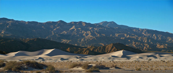
[[Image:Death_valley_dunes.jpg|thumb|left|600px|Sand dunes in Death Valley]] | [[Image:Death_valley_dunes.jpg|thumb|left|600px|Sand dunes in Death Valley]] | ||
| − | The lowest point of Death Valley - Badwater Basin - is the lowest point in the United States (and all of the Americas) at -282 ft (85.5 m) below sea level, it is overlooked by the 11,049 feet high Telescope Peak. On July 10, 1913 a temperature of 134° F (57° C) was recorded, this is the hottest ever recorded in the western hemisphere and golbally is second only to | + | The lowest point of Death Valley - Badwater Basin - is the lowest point in the United States (and all of the Americas) at -282 ft (85.5 m) below sea level, it is overlooked by the 11,049 feet high Telescope Peak. On July 10, 1913 a temperature of 134° F (57° C) was recorded, this is the hottest ever recorded in the western hemisphere and golbally is second only to Azizia, Libya which recorded 136° F (58° C) in 1922. |
[[Image:Badwater.jpg|thumb|250px|Badwater Basin - Lowest point in United States]] | [[Image:Badwater.jpg|thumb|250px|Badwater Basin - Lowest point in United States]] | ||
[[Image:Death Valley from space.jpg|thumb|right|250px|Death Valley as seen from the Space Shuttle]] | [[Image:Death Valley from space.jpg|thumb|right|250px|Death Valley as seen from the Space Shuttle]] | ||
Revision as of 19:07, December 4, 2008
| Death Valley National Park | |
|---|---|
| IUCN Category II (National Park) | |
| | |
| Location | California & Nevada, USA |
| Nearest city | Pahrump, NV |
| Area[1] | 3,000 sq. miles |
| Established | 1993 |
| Governing body | U.S. National Park Service |
| Website | NPS - Death Valley |
Death Valley is the lowest, driest and hottest part of the United States. It lies on the border of California and Nevada and was designated as a National Park on February 11, 1933. Death Valley is about 145 miles long and 16 miles wide and covers an area of about 3,000 square miles (7,800 km²). The valley runs north-south between the Amargosa Range to the east and the Panamint Range to the west; with the Sylvania Mountains and the Owlshead Mountains forming its northern and southern boundaries.
The lowest point of Death Valley - Badwater Basin - is the lowest point in the United States (and all of the Americas) at -282 ft (85.5 m) below sea level, it is overlooked by the 11,049 feet high Telescope Peak. On July 10, 1913 a temperature of 134° F (57° C) was recorded, this is the hottest ever recorded in the western hemisphere and golbally is second only to Azizia, Libya which recorded 136° F (58° C) in 1922.
Temperatures and Precipitation[2]
| Jan | Feb | Mar | Apr | May | June | July | Aug | Sep | Oct | Nov | Dec | Year | |
|---|---|---|---|---|---|---|---|---|---|---|---|---|---|
| daily high (average) |
65° F | 72° F | 80° F | 90° F9 | 9° F | 109° F | 115° F | 113° F | 106° F | 92° F | 76° F | 65° F | 90° F |
| 18° C | 22° C | 27° C | 32° C | 37° C | 43° C | 46° C | 45° C | 41° C | 33° C | 24° C | 18° C | 32° C | |
| daily low (average) |
39° F | 46° F | 53° F | 62° F | 71° F | 80° F | 88° F | 85° F | 75° F | 62° F | 48° F | 39° F | 62° F |
| 4° C | 8° C | 12° C | 17° C | 22° C | 27° C | 31° C | 29° C | 24° C | 17° C | 9° C | 4° C | 17° C | |
| record high | 89° F | 97° F | 102° F | 112° F | 122° F | 128° F | 134° F | 127° F | 123° F | 113° F | 97° F | 88° F | 134° F |
| 32° C | 36° C | 39° C | 45° C | 50° C | 53° C | 57° C | 53° C | 50° C | 45° C | 36° C | 31° C | 57° C | |
| record low | 15° F | 25° F | 30° F | 35° F | 42° F | 49° F | 62° F | 64° F | 41° F | 32° F | 24° F | 19° F | 15° F |
| -9° C | -4° C | -1° C | 2° C | 6° C | 10° C | 17° C | 18° C | 5° C | 0° C | -4°C | -7° C | -9° C | |
| precipitation | 0.27" | 0.35" | 0.25" | 0.12" | 0.08" | 0.04" | 0.11" | 0.10" | 0.14" | 0.11" | 0.18" | 0.19" | 1.94" |
| 0.7 cm | 0.9 cm | 0.6 cm | 0.3 cm | 0.2 cm | 0.1 cm | 0.3 cm | 0.3 cm | 0.4 cm | 0.3 cm | 0.5 cm | 0.5 cm | 4.9 cm |
See also


